
read the previous post on Thompson’s restoration
An Inscrutable Marsh after Centuries of Plunder
The Delaware Bay marsh sprawls across nearly the entire NJ and DE shoreline, an area unrivaled in the mid-Atlantic. Many knowledgeable people, naturalists, ecologists, and wildlife biologists, have studied and written of the marsh starting as far back as William Bartram, one of America’s first naturalists.
Still, It remains one of the most inscrutable habitats on the east coast because our ancestors exploited the expansive landscape for centuries. Right from our nations’ start and continuing until today, fishermen and farmers have exploited everything field, forest and marsh work for them. Farmers built dikes that kept out the tide so they could cut hay and cultivate crops. We’ve been exploiting the bay for so long, a unique post-plunder ecological blend of natural and human-made influences now shapes the marsh.
Restoring this vast wetland will bring fish to fishers, birds to birders and the income to the people who can provide support services: marinas, tackle shops, head boats, tour boats, restaurants, and hotels. But how and where do we start?
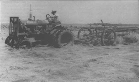

Salt Hay found many uses, everything from bedding for strawberries to insulating concrete in cold weather. The expansion of concrete highways in the thirties and skyrocketing demand for runways in WWII created solid income for many bayshore farmers. Demand crashed however in the fifties and most farmer abandoned thier dikes by the 70’s leaving substantial ecological damage.
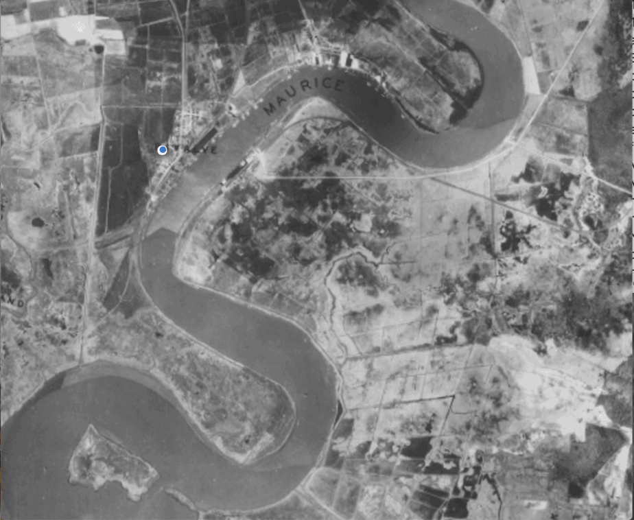

A 1932 photo of Northwest reach marsh on the Maurice River showing the dense matrix of ditched marsh and salt hay fields. Farmers abandoned these dikes in the early 50’s. By 1960 the entire marsh transformed into a mud flat that threatened the town of Heislerville
Climate Brings a New Reckoning of the Tide and Sea
The tide adds mystery to the bay marsh. The twice-daily tidal cycle both nourishes and destroys as it floods and ebbs into every artery, vein, and capillary of the entire marsh. Each flood enriches the marsh with vital sediments and each ebb brings new life to the bay. The bays current runs swift. Awe-inspiring and dangerous, sailors have long avoided the bay’s tidal currents and the dangerous shoals it creates.
But now climate change and sea-level rise add a new force to the natural and unnatural forces shaping the bay. A 4 mm/year increase in sea level each year, exacerbates a growing frequency of odd storms and tides. Hurricane Sandy stands above all weather events but equally damaging are the very high tides during easterly gales. The east wind, whether north or south holds up the outgoing tide and assists the incoming tide at its Atlantic source. The result – record tides damaging beach, marsh and manmade infrastructure alike. Strong northeasters packing winds up to 60 mph regularly batter Atlantic coastal communities while silent but damaging tides threaten the bay coast.
On Delaware Bay, coastal communities struggle to meet the consequences of this perfect storm of damage from the past and the increasing threat of the future. Most municipalities have nearly empty municipal budgets and get little help from state or federal agencies. Even with funding, the small townships resort to stopgap solutions that are both ineffective and unable to clear rigorous state regulations that protect our fragile wetlands.
Better solutions exist. To understand how one must learn the basics of marsh ecology.
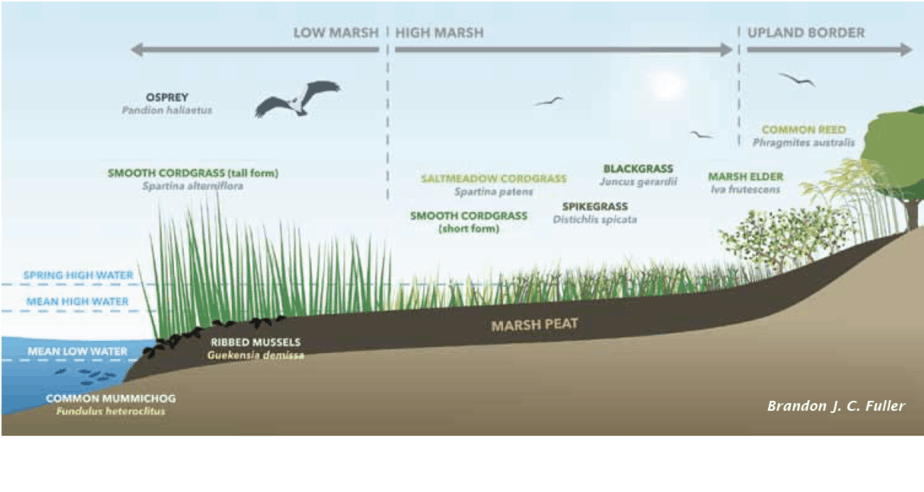
Salinity and Elevation Shape the Marsh
Over 20 species of plants grow on the Delaware Bay marsh, the area influenced by salty tidal seawater. However, three species dominate. The first two, marsh cordgrass or Spartina alterniflora, and salt hay, Spartina patens, cover most of the saline wetlands of the bay and naturally occur in this ecological system. The third, Phragmites australis or common reed grass invaded from Asia. It competes with natives especially well in tidal environments altered by man or water of low salinity. Phragmites provides plenty of biomass but little primary productivity for the fishery food chain.
Spartina, on the other hand, provides most of the bay’s productivity that ends in fish and shellfish. And all depends on a difference in elevation measured in inches.
Plants growing at the level of mean high tide – the average height of both spring and neap tides- grow more vigorously, roots entangling to make a strong fibrous mat. The above-ground portion grows relatively short, and so-known as short-form spartina. Plants growing at a lower elevation stay immersed in water longer. They grow taller but at lower density thus the label tall-form spartina. One can walk across a short form Spartina marsh with little trouble. Mud up to your waist awaits a walker in a tall form marsh.
The highest part of the Delaware Bay marsh belongs to Spartina patens or salt hay. In this rarefied portion of the marsh, salt waters flood only during the twice-monthly Spring tides. This marsh can be cut and baled without dikes because of the elevation firms up soils enough for farming equipment.
A Cultural Legacy Lost Leaving an Injured Marsh in Its Wake
Salt hay farmers used the bay marsh-like hay fields. Some cut naturally occurring spartina patens in the highest elevations. Most farmers, however, converted Spartina Alterniflora to patens by shutting out tide. To do this, they stopped the tide with dikes made of marsh muck. They converted marsh with abandon. Some made big money when federal road programs in the 1930s and WWII increased the demand for salt hay to insulate wet concrete in cold weather.
But this ephemeral demand evaporated in the 1950s and farmers deserted their dikes and fields of salt hay or spartina patens. After decades of removing hay and accelerating decomposition by keeping fields dry, marsh elevation fell by feet. Letting the tide back into these black holes of dead patens marsh, left remaining vegetation defenseless. Agencies bought out the farmers hoping nature would solve the problem. Erosion ensued.
Large sections eroded quickly into barren mudflats. Most salt hay fields eventually renewed growth of slow-growing low productivity tall alterniflora. Few of these grew back to the more ecologically stable short-spartina marsh.
Did the salt hay farmers know they lowered elevation? They must have known that harvesting plant biomass and keeping out the tide would starve the marsh for new sediment. After all many opened the gates during winter, presumably to restore sediment. Baymen educated by the sea would have seen the damage.
Taking Action
We have taken the first step. In 2018 and 2019 the American Littoral Society, Stockton University, and my group Wildlife Restoration Partnerships created a biodegradable coir log boundary around an acre of marsh damaged by salt hay farming ( see this photo journal describing the entire process ). We then contracted with Wittberg Marine to dredge a tidal creek adjacent to the site and used the mud to fill up the contained area. We struggled with many problems, the winter freezes, equipment problems, budget problems ( see this video for one big problem).
Now we monitor the outcome. This will, of course, go on for years but early signs point to success. Most of the area has already regrown spartina or sprouted from the seed we planted. Enjoy this gallery to describe the outcome.
read the final post on Thompson’s restoration – a photo journal of the project