
Pierce’s Point Reflects The Threat to all Delaware Bayshore’s Beaches – and Here’s How to Fix It
(see previous post )
We began our project fixing the oldest and most deadly breach for horseshoe crabs in the middle of South Reeds Breach. The dune gap allows the sea to gush through, pushing crabs into the marsh and certain death. The breaches also expand yearly, sometimes in a single storm, threatening the beach’s integrity. With additional funding from the National Fish and Wildlife Foundation (NFWF), we fixed four more gaps, three on Pierces Point and one on Kimbles. The three breaches on Pierce Point were the most difficult, as it is not three breaches but one long one that threatens the entire point and the town itself.
Like most of the towns in this area of the bay, Pierce’s Point sprung from a ramshackle community of locals who came to Pierces to enjoy the bay’s fishing, crabbing, and, for the hardy, swimming. Over time, however, the town followed others shoreline communities down a path of ever-increasing property values and a shift to people from all over the region. Houses grow bigger every year, and every year the threat from the seas grows.
Hurricane Sandy whacked Pierces in 2012, and our team, led by the American Littoral Society, restored the beach in 2014. The beach held the sand for several years, but gradually, the sea has worn it down to its present depleted condition.
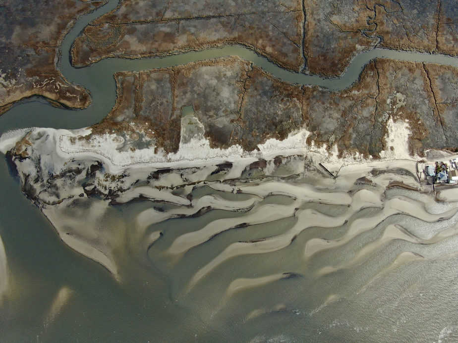
This drone shot shows the breaches in the dune along with Pierce Point Nj on Delaware Bay. The breaches expand each year and threaten to connect with the Dias creek which would likely result in the destruction of both beach and marsh.(move over image to remove caption)
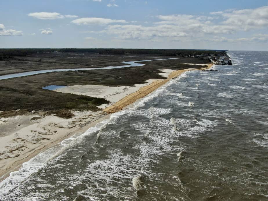
A winter storm pounds the beach at Pierce Point NJ. Previous storms pushed the beach inland creating three big overwashes. The town of Pierce’s Point shows just in the upper right of the picture.
The Increasing Threat of Climate Change
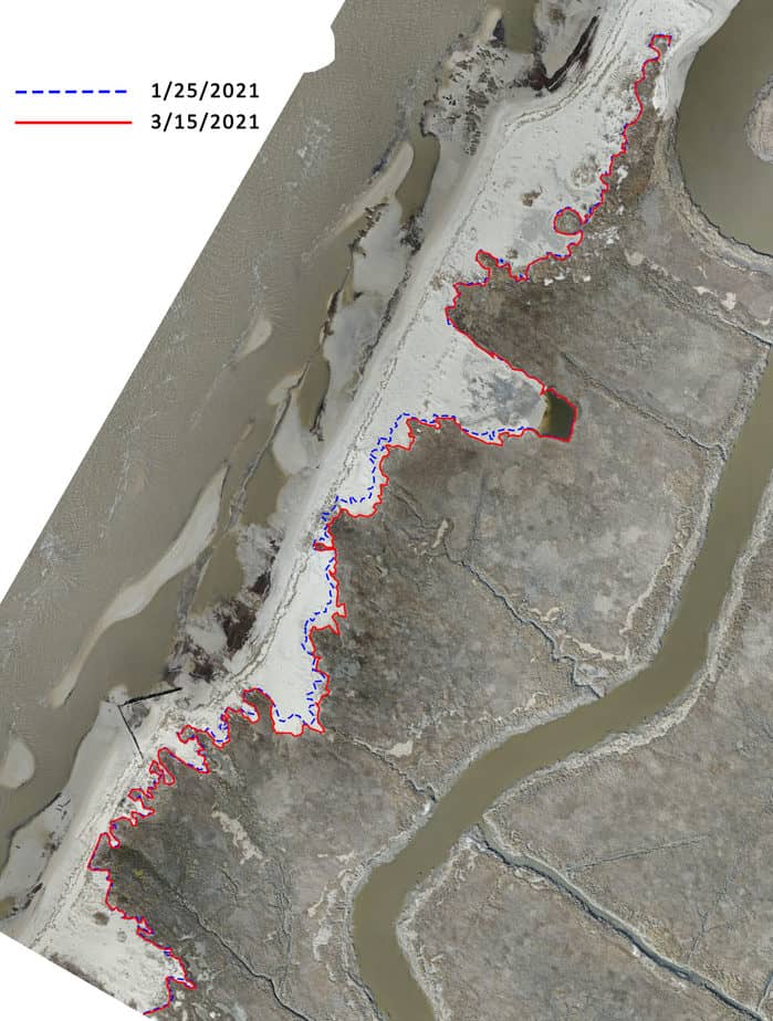
One reason for the loss comes from the ever-increasing threat of Climate Change. Winter storms have grown in frequency and severity, and as the bay warms, winter ice that usually forms along the shoreline has all but disappeared.. The impact is dramatic. Without floating ice moderating waves or ice chunks taking the brunt of storms, the beaches struggle to hold sand from being pushed into the marsh behind. The first map below compares drone shots taken in late Jan and mid-March. In just two winter months, the shoreline moved inland significantly.
And this is not a one-time event. The second graphic is a series of aerial photos showing change since 1931. You can see not much changed until the 1990s, but afterward, the peninsula eroded quickly. The last image is a projection of only ten years.
Our project is a bandaid on this coastal wound. The last three years have opened up gaps in the beach, accelerating the beach movement towards its final collapse into the tidal creek that runs along the inland side. Our reconstruction of the damaged sand dunes will close those gaps. This will also prevent horseshoe crabs from flowing into the gaps and dying when they can get back out. But our work is a stopgap meant to stop the damage.
In these drone photos, you can see erosion that took place in just two months this year.

Phil Heun, a third generation heavy equipment operator pushes sand on Pierce’s Point NJ to fix dune breaches
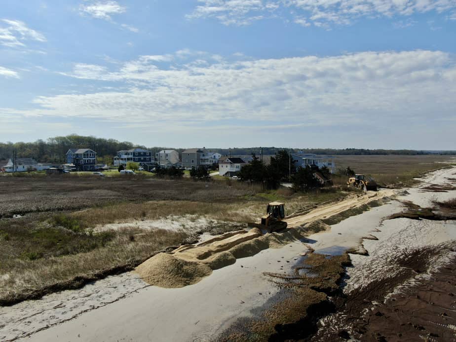
Fixing dune breaches at Pierces Point NJ
A More Lasting Solution
In the works, however, is a more long-lasting solution. With funding from the NFWF, we will provide greater protection and long-term resilience with the use of stone breakwaters. In Pierces and three other locations, we are pursuing permits for the construction of hybrid stone breakwaters that will provide both protection and improve the ecological productivity of the bay.
Breakwaters are old technology but tried and true. For example, in the early 1900s, as in most of the bay, farmers built dikes to keep out the tide so they could farm the marsh along the upper bay shoreline around Elsinboro at a historic site called Finn’s point. In the first graphic below, you can see these dikes in a 1931 aerial photo of the area. Finns Point is just visible at the upper right corner. In the middle aerial photo taken in 1940, you can see two important features. First, the farmers abandoned the diked fields, and the tide overwhelmed the site and threatened the inland communities. In response, the community built stone breakwaters to replace the farmer’s earthen dikes. You can see the result in last image of the series from a 2017 aerial – the breakwaters remain, and the protection allowed the marsh to recover.
Compare this will the sad fate of Cox Meadow just east of Moore’s beach and west of West Creek in the second graphic below. There too, farmers abandoned earthen dikes, but no one came in to replace them. The result is a slow-moving ecological catastrophe. The vegetation quickly eroded away, and the resulting mudflat expands every year, consuming productive marsh and threatening the inland communities with storm surge and flooding. This could have been prevented with breakwaters.
Our work at Pierce’s will help end this period of great erosion of the bay and hopefully create a more stable future for the next generation of people who care for the bay.
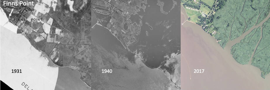
Sometime during the Great Depression, agencies rebuilt the abandoned earthen dikes of farmers who used the drained marsh to grow crops. The crops can be seen in the first photo taken in 1931. The second photo taken in 1940 shows the destruction of the marsh after the farmer abandoned the dikes. It also shows a stone breakwater that must have built in response to the loss. The breakwater exists to this day as seen in the third photo taken in 2017. Without the stone breakwater, the marsh would have been destroyed, as happened in Cox Meadow described in the next figure.
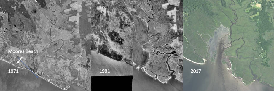
Three aerial photos taken in 1971, 1991, and 2017 show the relatively rapid destruction of beach and marsh at Cox Meadow on Delaware Bay caused by the abandonment of salt hay farm dikes without any response.