
Previous Update
We estimate the survival rate and population size of shorebirds on Delaware Bay through regular surveillance of birds with leg flags inscribed with unique alphanumeric codes. The estimation methods are complex and susceptible to manipulation by statisticians serving the fishing and biomedical industries. But done right, it provides a valuable measure of population status for red knots, ruddy turnstones, and other shorebird species.
The Delaware Bay shorebird teams, one on each side of the bay, started using the flags in 2003. Since then, we have banded 17,000 red knots, 18000 ruddy turnstones, and 20,000 sanderlings over the last 26 years. Each year our team resights flagged birds throughout the season, recording codes and the ratio of flagged to unflagged birds in the observed flock. Resightings also come from volunteers like Dave Ward, who enjoy the solitary and intimate experience with the shorebirds of Delaware Bay. Identifying flagged birds requires a rare skill. One must be patient and sharp-eyed and requires a good spotting scope to get the entire three-digit code with certainty. Youth always helps.
The scheme depends on catching birds to attach the leg flags. We accomplish this by capturing about 50-100 birds of each species, sanderling, ruddy turnstones, and red knots on a three or 4-day schedule. In this way, we can both ensure enough birds to continue the resightings effort and allow us to monitor the condition of the birds. We ask whether birds are gaining weight and how they compare to the birds caught in the previous 25 years.
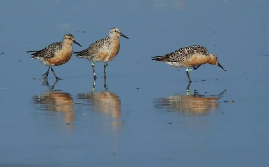
Lime colored flags on two red knots, one showing flag codes YXO and the other VST. US banders banded with lime or dark green. Other countries also have colors, Canada has white flags, Brazil blue, Argentina Orange and Chile is red.
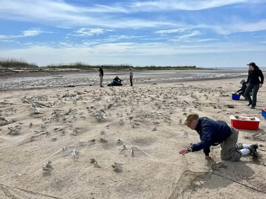
Ren Monte and Alindi Fojtik secures the net after we caught Red knots, Ruddy Turnstones, Sanderling and Dunlin with our Cannon net on Moores Beach as other prepare the covering material to cover the birds while we extract them.
Since my last update, we captured shorebirds twice. On May 14, we caught 20 red knots, 83 Ruddy turnstones, and 34 sanderlings. We completed our sample with a second catch on May 16, when we caught 107 red knots, 51 ruddy turnstones, and 15 sanderlings.
We found good news in the summary of the birds’ weights. All three species’ weights were on the high side of the average weights of the last 25 years. These good weights so early in the stopover period tell us that birds are arriving in relatively good condition and have already started to gain weight. As I described in the last update, the weight gain likely results from the early crab spawn. We are off to a good start!


We conducted a boat count of the entire Bayshore on May 15, starting at Fortescue at about 200 PM on a rising tide about 2 hours after the low. Humphrey Sitters and Stephanie Feigin counted while I piloted our 17 ft Boston Whaler. Until the boat count, we had estimated from our ground surveys less than 1000 knots baywide but found another 3000 knots from the boat.
We started our count on the bay at Fortescue, and soon, we found about 200 red knots at Egg Island, an inaccessible marsh just east of Fortescue. Egg Island is the largest contiguous marsh in the bay, one of the largest in the mid-Atlantic. Its remoteness makes it a preferred roost for knots and other shorebirds which have already built weight to get to the Arctic and are consequently vulnerable to the aerial predators. Being on the vast peninsula of marsh helps.
Our survey continued down the Bayshore to East Point Lighthouse, finding 300 knots and 450 ruddy turnstones. At Thompsons Beach and Moores, we found another 600 knots. The biggest surprise of the count was finding over 1500 knots in a small isolated tidal marsh just west of West Creek and east of Moore Beach.
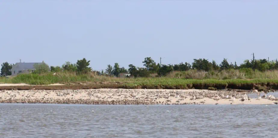
Red Knots, Dunlin and Ruddy Turnstones feeding at East Point

Red knots and other species roosting on the eroded marsh of West Creek east of Moores Beach
The beleaguered marsh is one of many on the bay still suffering from the sudden abandonment of dikes built by farmers as far back as the 1800s. After years of restricting the tide to grow and cut hay, the farmers abandoned the dikes when it was no longer profitable. After decades of no tidal nutrient inflow, compaction from farm equipment, and increased decomposition, the marsh declined in elevation as much as 3 feet. When suddenly flooded with tidal water, plants could not survive, and the marsh became a mud flat. Eventually, erosion made it into a subtidal bay.


We had only seen shorebirds in the areas occasionally and in low numbers. On this trip, however, we counted about 3000 shorebirds, including the 1300 knots. The flock’s knots, turnstones, and dunlin roosted peacefully on one of the last remaining sections of the old diked marsh.
After surveying the coast from Dennis Creek to Bidwells Creek, we finished our count. We found another 600 knots and a similar number of turnstones. From Fortescue to Bidwells, we counted 3974 red knots, 3740 ruddy turnstones, and about 500 sanderlings.
We returned to the East Point site on May 17 and 18 to get a better look and assess if we could catch birds there. We found our potential trapping site suitable, but on the second day, we returned and found over 2000 knots and 3000 ruddy turnstones and good numbers of dunlin, sanderling, and semi-palmated sandpipers. The birds spread over 5 acres of intertidal beach and mudflat that floods completely at high tide. The site lies just upriver from the historic Maurice River or East Point lighthouse. The lighthouse was built in 1849, the second oldest in NJ, and on the National Register of Historic Sites. We will return to trap tomorrow.
Next Update
Shorebirds are running up to horseshoe crab eggs at East Point. The East Point Lighthouse is in the background. Video by Humphrey Sitters

The East Point Light is the second oldest in the NJ and on the National Register of Historic Sites. Erosion threatens this active light house